Product · Satellite Estimating

Quote any fence from a satellite map — no tape measure, no site visit.

Search the address, click the property lines, and get fence footage plus a full bill of materials in minutes. The estimate that used to take two hours now takes five — from your desk.

Under 5min
Per estimate
50states
+ PR & Canada
650+
Parcel data sources
Satellite fence estimating: a real property on a satellite map with fence lines traced on each side, per-side footage labels, and the sidebar listing the fence runs and customer info 
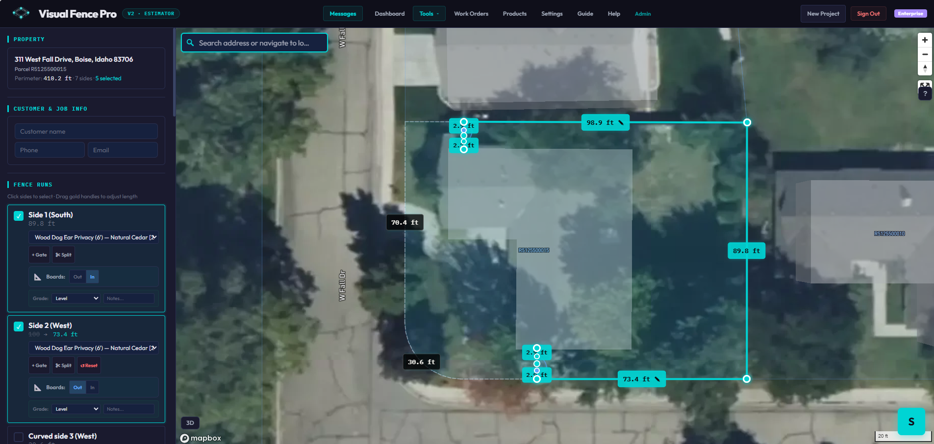
Live product · real property, real footage
How it works

From address to material list in three clicks.

1

Search the address

Type any address and the satellite map flies to the property with the parcel boundary already loaded.

2

Click the fence lines

Click the property sides you're fencing, drop gates and returns, drag handles to adjust. Footage updates as you go.

3

Get the BOM

The bill of materials writes itself — every post, rail, picket, and bag of concrete, priced with your numbers.

Elevation

See the slope before you bid.

Working a sloped lot? Click any fence line on the map and the sidebar shows the elevation change point to point along that run — the rise and fall between each section. Price stepping, racking, and grading from your desk, before you ever walk the property.

Elevation · point to point
What it means for your business

More bids out the door. Less time in the truck.

Every hour you spend driving to measure is an hour you're not selling. Satellite estimating gives those hours back.

Quote from the couch

Search the address, trace the fence, done — without leaving the office. Knock out estimates at 9pm in your slippers instead of burning a Saturday driving lot to lot.

No site visit to bid

Bid more jobs, faster

An estimate that took two hours with a tape measure and a spreadsheet now takes under five minutes. More bids out the door means more jobs won.

More bids = more jobs

Order the right materials

The BOM counts every post, picket, rail, and bag of concrete from the spec. No over-ordering "just in case," no second trip to the supplier in the middle of a job.

Tighter margins

Win it on the phone

Customer calls for a ballpark? Pull up their address, trace the fence, and give them a real number before you hang up. The fast, confident bid is the one that closes.

Beat the competition
Built for how you work

However you run your shop.

Solo contractor

Bid all week from one screen

You don't have time to drive to every tire-kicker. Triage and quote jobs from your desk, then only drive out for the ones that are real.

Multi-crew owner

Standardize every estimate

Every estimator works from the same satellite measurements and the same spec-driven BOM — so bids are consistent no matter who builds them.

High-volume / online

Quote at scale

Turn around a high volume of bids without adding estimators. The map does the measuring; your team just reviews and sends.

Questions

About satellite estimating.

How accurate are the satellite measurements?
Parcel boundaries are usually within a few feet. You can adjust any segment by hand, switch to manual drawing mode, or upload a survey PDF for properties without parcel data — so you're never stuck.
Does it work in my area?
We cover all 50 US states, Puerto Rico, and 6 Canadian provinces using 650+ parcel data sources, with more cities added every week.
Do I still need to measure on-site?
Not to bid. The satellite estimate is accurate enough to quote from. Most contractors do a quick on-site confirmation before install — but by then you've already won the job.

Quote your next fence from your desk.

Free plan includes 10 estimates a month — no credit card. Draw your first fence in under five minutes.

Start estimating free →